Type: Ecclesiastical site
Townland: Cill MaoilchéadairMaoilchéadari's Church
National Monument No. 65. The Early Christian and Medieval ecclesiastical complex at Kilmalkedar lies at the foot of the W slopes of Reenconnell hill, overlooking Smerwick Harbour.
The Reenconnell ridge peaks at 907 feet/276m to NE of the site and the area around Kilmalkedar is sheltered on its N and S sides by spurs of this hill.There is no trace of an original enclosing element and the various components of the site are spread over an area of about 10 acres, with the Chancellors House (9 in text and O on map) and St. Brendan's oratory (KE042-020----) lying outside this area, about 400m to SSW and NW of the church respectively.
The main nucleus of the site is bounded to N by a SW flowing stream, to W by the main road, and to E and S by laneways; the rectangular graveyard and church are at the centre of this area and the village of Kilmalkedar lies directly S of these.
The site is traditionally associated with St. Brendan but was reputedly founded by Maolcethair whose death is recorded in the Martyrology of Donegal under the year 636 - Maolcethair, son of Ronan, son of the King of Uladh, of Cill Melchedair, near the shore of the sea, to the west of Brandon Hill. He was of the race of Fiatach Finn, monarch of Erin (Champneys 1910, 25).
Remains from the Early Christian phase include the ogham stone, sundial, alphabet stone and a missing cross-slab. The site of an oratory marked on the OS maps is now incorporated into an extension of the graveyard. The corbelled building to NE of the graveyard is traditionally regarded as a chapel and, though the latter interpretation seems unlikely, it may have been a residential cell associated with the Early Christian settlement.
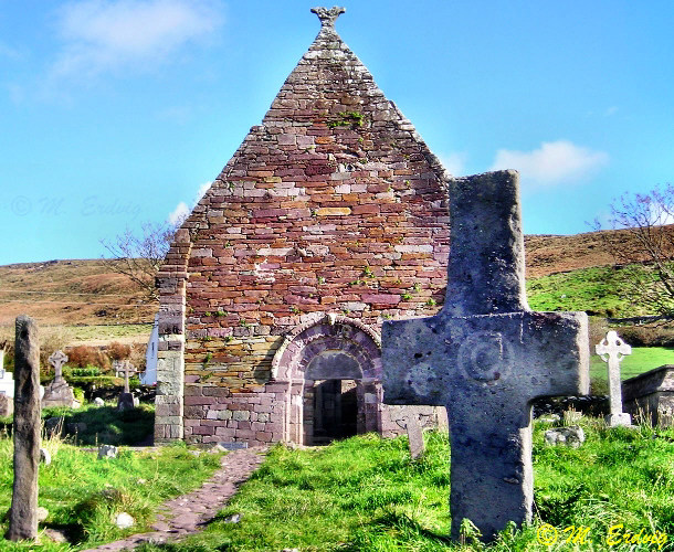
A large stone cross stands within the graveyard and 2 bullaun stones are located outside the main nucleus, one discovered when the road was widened in 1984, and the other, the Keelers, located in a field on the W side of the river. The pilgrim's track that leads up to the pilgrimage site on the summit of Brandon mountain (KE034-112001-) passes through Kilmalkedar. The building of the Romanesque church, probably in the mid-12th century, appears to go unnoted in the annals.
In 1298 the village of Kilmalkedar was fined in connection with the escape of prisoners (Cal. doc. Ire. IV, 249). The church is included in the Papal Taxation List (1302-7) for the diocese of Ardfert (Cal. doc. Ire. V, 297), the rector at that time being 'Philip, chancellor of Ardfert'.
Throughout the medieval period the rectory of Kilmalkedar was the prebend of the chancellor of Ardfert (Cal. papal letters, 12, 756; 14, 37) who probably resided in the nearby Chancellor's House. The construction of the Chancellor's House and St. Brendan's House in medieval times suggests a flourishing church here at that time. The church is included in the list of parochial churches in the diocese in 1622 (TCD Ms 2158, 94).
In 1756 half the tithes of the parish of Kilmalkedar still formed part of the livings attached to the chancellorship (Smith, 68) but it is not clear whether the church was still in repair at that time.
St. Brendan's holy well is located beside St. Brendan's House and a 2nd holy well, with a cross-inscribed stone, is situated in the field to E of the roadway. The turas formerly held at Kilmalkedar included rounds at the latter well and at 2 crosses (OSNB Kilmalkedar, 28), one of which may be that at the so-called 'altar' which lies at the S end of the field to W of the graveyard. A small cell is incorporated into the E wall of this field, a few metres N of the altar.
Other features of interest at the site include a font, some cross-inscribed or cross-shaped gravemarkers and some miscellaneous carved fragments.
A holy water stoop, an inscribed stone cross and 2 holed stones are now missing.
(1) Ogham Stone: (KE042-026001-) Located on the N side of the pathway leading through the graveyard to the church, this stone measures 1.83m in height and .24m in width at base. An hourglass-shaped perforation near the top of the stone measures .12m in depth and .07m in maximum diameter.
The inscription reads:ANM M(AI)LE INBIR MACI BROCANN The AI of MAILE is now represented by only 4 notches but there is sufficient space to accommodate the other two implied by the reading AI (Macalister 1945, 180-1). A 2nd, possibly earlier, inscription on the S side of the stone can be read either as ANM or M(A)Q(I).
(2) Sundial: (KE042-026002-) Standing at present at the W edge of the graveyard, this monument previously acted as a headstone to a modern grave and was moved at least once before reaching its present position (Atkinson 1887, 247). The stone socket in which it stands was partly revealed during OPW work at the site in 1982 but has now been reburied. The pillar stands 1.23m high and both the roughly semi-circular head and rectangular shaft are dressed to a smooth finish.
The upper part of the SE face is divided into 4 roughly equal sectors by paired or triple lines which radiate out from the outer of 2 inscribed circles which enclose the gnomon hole. These radiating lines terminate at 5 outline semi-circles and the entire design is framed by a semi-circular groove which follows the outline of the stone.
The shaft on this SE side is also bordered by an inscribed line, and 2 lines which run vertically down the centre of the shaft terminate at each end with a fret motif. The NW face of the shaft has a similar, though not identical design.
The upper part of the NW face is occupied by an asymmetrical design consisting of intersecting arcs of circles which basically form a cross of arcs. The upper and lower arms are infilled with outline triangles and the angles between the arms with outline motifs of varying form: the upper right angle contains 2 pointed concentric ovals, the upper left contains a spiralled oval and the lower angles are occupied by rounded triangles.
As on the SE face, the entire design is framed by an inscribed semi-circle which follows the outline of the stone. Both the shaft and upper part of the NE side of the stone are framed by an inscribed line.
The SW side is similarly divided into 2 panels but here the lines terminate above and below the junction of head and shaft in a pair of opposed fret designs.
(3) Alphabet Stone: (KE042-026003-): Now erected on a modern base beside the chancel arch of the church, this pillar stone stands 1.22m high but is broken across the top. The W side of the stone is inscribed with the invocation
DNI, a contraction of Domini, and with a later inscription consisting of the Latin alphabet in half-uncial script. On the basis of the epigraphy, a date in the 2nd half of the 6th century has been suggested for the latter (Bieler 1949, 271).
The S face is inscribed with a Latin cross with scrolled terminals. Above this a small part of a cross-in-circle motif is visible, the cross probably having similar scrolled terminals to the one beneath. Only the scrolled terminal and stem of the cross on the N face survive. Drawings of this slab have been published by both Romilly Allen (1892, 268) and Macalister (1949, 96).
It was still at the site in 1965 when Rynne (NMI) noted that two freshly-broken fragments of it lay on a large tomb in the chancel of the church, but it is now missing.
It measured .47m x .34m x .08m thick and one face was inscribed with a cross-in-circle, beneath which was a small cross with expanded terminals and the inscription DNE (for Domine). The cross within the circle also had slightly expanded terminals to the lower and side arms, and the upper arm terminated in a B-shaped motif. (KE042-026005-)