Type: Ogham Stone
Townland: Cinn AirdHigh Headland
There are no longer any visible remains of the parish church of Kinard/Teampall Chinn Aird (KE053-053001-) in the rectangular graveyard (KE053-053004-) known as Cinn Aird an Teampaill.
The presence of two ogham stones (see also CIIC 188) and a bullaun stone at the site suggests that it is probably an early ecclesiastical site. The surrounding district is known locally as Tearmann Fhíonáin, from the patron saint of the Parish on whose feast-day a pattern was formerly held at the site (OSL; An Seabhac 1939, 150) (Cuppage et al, no. 863).
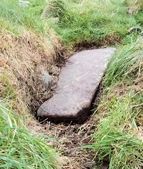
Recorded by Cuppage (1986, 328, no. 863, ogham stone 1) as follows: 'This slab lies prostrate in the NW part of the graveyard [KE053-053004-]. It measures 1.8m in length, .33 to .52m in width and .12 to .16m in thickness.
The ogham inscription which runs along 1 side and across the top of the stone was read by Macalister (1945, 182-3) as:
SANGTI LLOTETI AVI SRUSA.'
Rhys (1898, 235) wrote the following account about the inscription; 'me the second instance of finding the character for the guttural nasal. The other instance occurs in the genitive Sangti on a stone at Kinnard East, near Dingle, in Kerry. I read the whole inscription as
Sangti Llotuti avi Srusa "(the grave of S. Li. descendant of Sru"; but Mr. Macalister (pp. 64-66) inserts an a, and reads in the other direction, as did also Mr. Brash. The fact is, the Ogam, begins in a very unexpected place, and the explanation is, as I thought when I saw the stone years ago, that the inscriber was probably ignorant what he was writing from a copy on a stick, and that consequently he chanced to begin the Ogam at the end. N.B. - I have examined the stone again: the a is impossibe'.
Found: In its current location in the graveyard in the townland of Kinard East and barony of Corkaguiney.
(GPS coordinates -10.196619, 52.126261)
Find location possibly original site.
Last Recorded: Lying in the north-west side of the graveyard. The present location of this stone may be accessed via the National Monuments Service Historic Environment viewer on www.archaeology.ie.
'Grit' (Macalister 1945, 182), 1.80m x 0.52m x 0.16m (Cuppage 1986, 328).
TranscriptionMacalister reading top-down (1945, 182): SANGTI LLOTETI AVI SRUSA McManus' reading up-top (1986, 21): A CURCITI VEVODDIUGWAC The inscription runs along one angle and across the top of the stone (Cuppage 1986, 328).
Macalister (1945, 182) read the inscription from the top of the stone downwards. McManus (1986, 21), on the other hand, read from the bottom up and across the top..
Macalister (1945, 182) cites C. Graves as the first recorder of the stone in 1849. It was last recorded in 2017 by Kathleen Reen and Isabel Bennett, participants on the Corca Dhuibhne 3d project, using Structure from Motion 3d technology and processed using Agisoft Photoscan (see 3D view tab).
ReferencesBennett I. and Uí Shíthigh B. (1995): Ogham Stones of the Dingle Peninsula. Ballyferriter, 21.
Cuppage, J. (et al.) 1986 Corca Dhuibhne. Dingle Peninsula Archaeological Survey. Ballyferriter. Oidhreacht Chorca Dhuibhne.
Macalister, R.A.S. 1945 Corpus Inscriptionum Insularum Celticarum. Dublin. Stationery Office.
McManus, D. (1986): 'Ogam: archaizing, orthography and the authenticity of the manuscript key to the alphabet', Ériu 37, pp 1–31.
Kathleen Reen